Covid numbers drop except in eastern Kentucky
Published 7:42 am Tuesday, September 20, 2022
Al Cross
Kentucky Health News
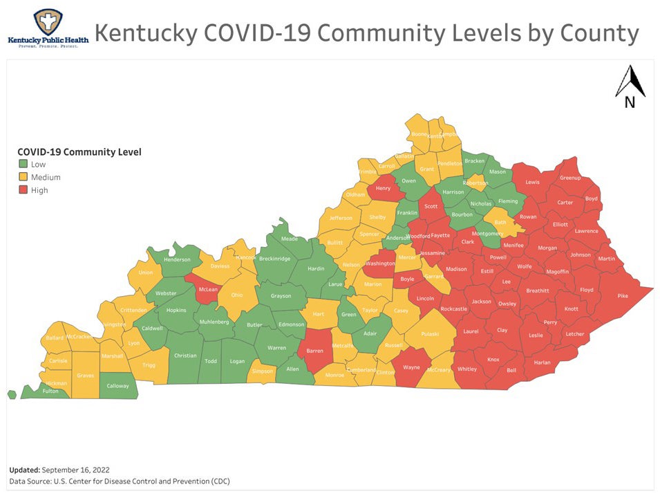
The weekly Covid-19 risk map for Kentucky took a solid turn for the better last week, as more than a third of the state’s counties had a lower risk level than a week earlier.
Only two counties, Barren and Trigg, showed a higher level of risk on the three-level scale of the federal Centers for Disease Control and Prevention. Barren rose to high risk, shown in orange, and Trigg rose to medium, shown in yellow.
Thirty-six counties dropped one risk level. Five dropped two levels, from high to low risk, which the map shows in green. Those five were Butler, Warren, Franklin, Bourbon and Harrison.
The CDC rated 31 counties at low risk, more than two and a half times the 12 rated low a week earlier. It rated 44 at medium risk and 45 at high risk, well below the 70 rated high the previous week.
Amid all those changes, one aspect of the map looked pretty much the same: Every county that lies completely in the East Kentucky Coal Field remained at high risk, except McCreary, which fell to medium. Many Central Kentucky counties remained at high risk, but several had less risk.
The risk map is based on new coronavirus cases, hospital admissions and hospital capacity. In high-risk counties, the CDC recommends that you wear a well-fitting mask in public indoor spaces, and if you are at high risk of getting very sick, consider avoiding non-essential indoor activities in public where you could be exposed.
If you live in a medium or high-risk county, the CDC advises wearing a well-fitting mask when indoors and in public and to consider getting tested before having social contact with someone at high risk for getting very sick and consider wearing a mask when indoors when you are with them.
The CDC says the risk map is designed to determine the impact of Covid-19 on communities and to guide their residents’ preventive measures. The CDC also does a Transmission Levels map that describes the Covid-19 spread in each county. “Health-care facilities use transmission levels to determine infection control interventions,” the agency says.
The transmission map has four levels, from high to low. It shows every county in Kentucky with high transmission, except Calloway and Lyon counties in West Kentucky.